February 23, 2026 | 08:16 am

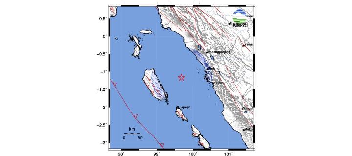
TEMPO.CO, Jakarta - A tectonic earthquake measuring 5.0 magnitude struck the north coast of the Mentawai Islands, West Sumatra, on Sunday, February 22, 2026, at 10:35:41 PM Western Indonesian Time (WIB). Tremors were felt in several areas in West Sumatra, but no significant damage was reported.
According to analysis by the Meteorology, Climatology, and Geophysics Agency (BMKG), the epicenter was located in the sea approximately 24 kilometers north of North Siberut, Mentawai Islands. It was at a depth of 40 kilometers. Initial information from the BMKG indicated a magnitude of 5.2.
The Acting Director of Earthquakes and Tsunami at the BMKG, Rahmat Triyono, explained that the earthquake was classified as a shallow earthquake. Its source was located in the megathrust zone. "The earthquake occurred due to the subduction of the Indo-Australian Plate beneath the Eurasian Plate," he said in a written statement on Sunday evening.
He added that the analysis of the source mechanism indicated that the earthquake had a thrust mechanism. The earthquake was felt in the Mentawai Islands, West Pasaman, and Agam at an intensity of III on the MMI scale. At this scale, the tremors are clearly felt inside homes, as if a truck were passing by during the day.
Meanwhile, in Pariaman, Padang, Padang Pariaman, Padang Panjang, and Bukittinggi, the earthquake was felt at an intensity of II on the MMI scale, meaning tremors were felt by several people and light hanging objects swayed.
The Meteorology, Climatology, and Geophysics Agency (BMKG) confirmed that the earthquake did not trigger a tsunami. "The public is advised to remain calm and not be influenced by unsubstantiated issues," it said.
This earthquake was the strongest among the earthquakes felt throughout Sunday, February 22, 2026. Among the earthquakes, one occurred in Gayo Lues, Aceh, on Sunday morning. The M4.2 landquake was reported to have an intensity of II-III on the MMI scale.
Another earthquake was a M3.9 earthquake in Mukomuko, Bengkulu, with an intensity of II on the MMI scale. The Meteorology, Climatology, and Geophysics Agency (BMKG) recorded this earthquake at 10:35 PM, with its epicenter located 35 kilometers southwest of Mukomuko at a depth of 27 kilometers.
Then, there was a 7.2 magnitude earthquake from the sea, 109 kilometers northeast of Kota Kinabalu, Sabah, Malaysia, which was felt at a magnitude II MMI scale in several areas in North and East Kalimantan. The epicenter was at a depth of 628 kilometers.
At a magnitude II MMI, the shaking was felt like a daytime earthquake by only a few people inside homes and caused light hanging objects to sway.
Read: BMKG Records M4.7 Earthquake in Tangerang
Click here to get the latest news updates from Tempo on Google New
BMKG Records M4.7 Earthquake in Tangerang
1 hari lalu

The Indonesian Meteorology, Climatology, and Geophysics Agency (BMKG) recorded a 4.7 magnitude earthquake in Tangerang Regency, Banten.
How Earthquakes Form Gold Nuggets in Quartz
2 hari lalu

The formation of gold nuggets is influenced by electric currents caused by earthquakes.
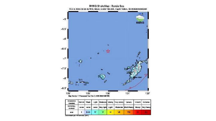
Magnitude 5.5 Earthquake Hits Indonesia's Maluku, No Tsunami Risk
4 hari lalu
The earthquake was classified as moderate and was caused by rock deformation within the Banda Sea Plate.
4.8-Magnitude Earthquake Jolts Indonesia's East Priangan Region
5 hari lalu

Indonesia's East Priangan region was rocked by a tectonic earthquake with a magnitude of 4.8 early Wednesday morning, February 18, 2026, at 1:00 am.
Pacitan Earthquake: KAI Halts Trains, Denies Derailments
16 hari lalu
PT KAI clarifies reports of a train derailment in Yogyakarta following the Pacitan earthquake in the early hours of February 6, 2026.
Magnitude 6.4 Earthquake Hits Yogyakarta, Affecting 40 Residents
16 hari lalu

Yogyakarta's dIsaster management agency recorded at least 40 affected residents, while a number of public facilities and homes sustained damage.
M6.2 Megathrust Earthquake in East Java, BMKG Reports No Tsunami Threat
17 hari lalu

The earthquake that occurred is a type of shallow earthquake due to subduction plate activity.
M5.4 Earthquake Jolts Maluku from Banda Sea, No Tsunami Reported
19 hari lalu
The earthquake that occurred was an intermediate earthquake caused by rock deformation in the Banda Sea Plate.
BMKG: M4.4 Earthquake Hits Mentawai Islands, Caused by Fault Activity
21 hari lalu
Meteorology, Climatology, and Geophysics Agency (BMKG) reported a tectonic earthquake with a magnitude of 4.4 struck Siberut Island, Mentawai Islands.
BMKG Records 97 Earthquakes in West Java During January
21 hari lalu
The Indonesian Meteorology, Climatology, and Geophysics Agency (BMKG) recorded 97 earthquakes in West Java during January 2026.